Global Data Challenge Underway to Automate Crop Type Monitoring in South Africa using Satellite Data & Machine Learning
Participants of the Radiant Earth Spot the Crop Data Challenge are building models to classify crop types based on time-series satellite imagery.
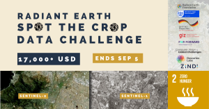
WASHINGTON, DISTRICT OF COLUMBIA, UNITED STATES, August 3, 2021 /EINPresswire.com/ -- The United States based nonprofit Radiant Earth Foundation and the Western Cape Department of Agriculture in South Africa are inviting the world’s data scientists to join the Radiant Earth Spot the Crop Data Challenge. This open competition is currently running until September 5.Participants are building machine learning models to identify crop type classes in the Western Cape province of South Africa using training data generated by Radiant Earth, based on ground reference data collected and provided by the Western Cape Department of Agriculture. Hosted on the Zindi platform, the data science competition consists of two parallel tracks: In track 1, participants are using the time-series of Sentinel-2 multi-spectral data as input to their model. In track 2, both Sentinel-2 and Sentinel-1 radar data are being used as input. The participation awards are USD 4,000 USD, USD 2,800, and USD 2,000 for each track’s first, second, and third prizes.
Combining Earth observation (EO) satellite data and machine learning technologies are vital for developing agricultural monitoring tools to determine and anticipate change trajectories. On the one hand, EO technologies help us understand the planet’s different elements and monitor natural and anthropogenic changes. On the other hand, machine learning allows us to run predictive analyses based on the data at scale. Examples that demonstrate the power of the technologies include assessing drought risks and mapping optimal soil conditions for certain crops, among other applications. With the flux of high-quality open satellite data, we can build an agricultural monitoring system that is automated at a fraction of the cost and time that a traditional agricultural census would take.
An automated agricultural monitoring system is essential for the Western Cape, which experienced the frightening ‘Day Zero’ water crisis in 2018, especially in light of reports that it could experience another water crisis this century. Agriculture is one of the Western Cape’s economic backbones and a lead agricultural exporter of South Africa. When drought strikes, from the wine industry to its fruit and livestock farming, it affects people locally and regionally. The winning results of this data competition can demonstrate the potential of Earth observation data and machine learning applications to develop an operational agricultural monitoring system, particularly for regions without dependable monitoring systems in place. It can also be used to develop applications that allow for more frequent updates to monitor agricultural change trajectories in the Western province.
The competition and data preparation are made possible with support by the convening sponsor, GIZ FAIR Forward, which is implemented by Deutsche Gesellschaft für Internationale Zusammenarbeit (GIZ) GmbH on behalf of the German Ministry for Economic Cooperation and Development (BMZ). Cash prizes that will be awarded to the top winners are made possible through the additional support from platinum sponsor Computer Vision for Global Challenges and gold sponsor Descartes Labs.
Radiant Earth will host a webinar on August 5, 2021, at 9 AM EST. Experts will provide technical tutorials and examples for those interested in participating in the data challenge. To attend the webinar, participants can register here: https://bit.ly/SpotTheCropWebinar
About Radiant Earth
Radiant Earth Foundation is a nonprofit corporation working to empower organizations and individuals with open ML and Earth observation data, standards, and tools to address the world’s most critical international development challenges. Radiant Earth fosters collaboration through a cloud-based open geospatial training data library, Radiant MLHub. Radiant also supports an ecosystem of practitioners to develop standards, expand interoperability around ML on Earth observation, and provide information and training to help advance the capacity of those working in the global sector using ML and Earth observation.
Louisa Diggs
Radiant Earth Foundation
+1 202-596-3603
Louisa@radiant.earth
Visit us on social media:
Twitter
LinkedIn
EIN Presswire does not exercise editorial control over third-party content provided, uploaded, published, or distributed by users of EIN Presswire. We are a distributor, not a publisher, of 3rd party content. Such content may contain the views, opinions, statements, offers, and other material of the respective users, suppliers, participants, or authors.


